The death of Robert James Waller in March prompted a lot of retrospection toward his bestselling novel The Bridges of Madison County and the movie based on the book. Those bridges may have been featured in the title, but they definitely had merely supporting roles in the story.
Okay, yes–bridges are intended to be supporting.
Yet while pedestrians and drivers alike often pass over the bridges of Emory without much recognizing them, those spans have a history and presence worth celebrating.
When Henry Hornbostel laid out the Druid Hills campus, he traversed the ravines and streams with several single-arch bridges, whose elegance belies their concrete construction.
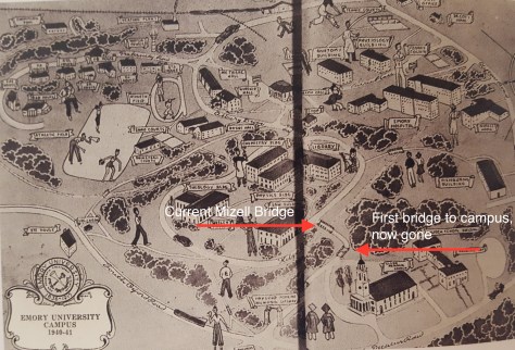
The original entrance to the campus from Emory Village must have given the impression of entering a country estate, as the drive passed through woods to the left and the right. The roadway then crossed the bridge shown below, over a gully that would later be filled into construct the driveway around Glenn Memorial. After turning left beyond this bridge, the road then crossed a second bridge, which still stands astride the ravine behind Carlos Museum.
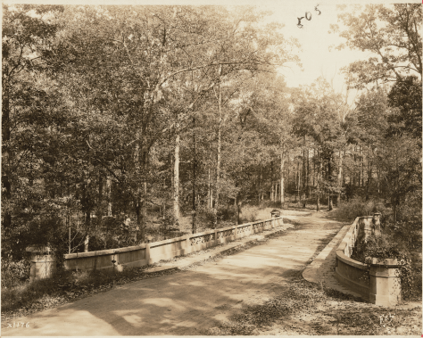
A campus map from 1940–41 (below) shows both the now-vanished bridge and the still-standing Mizell Bridge, named in memory of Robert Cotter Mizell, Class of 1911 and long-time administrator and trustee of the University..
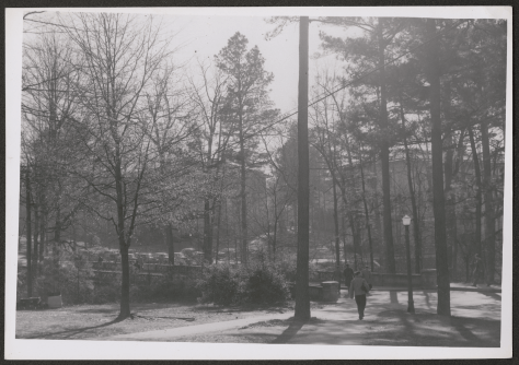
The view in the photo below, taken around 1946 and archived with these other photos at the Rose Library, looks toward the Quadrangle. Candler Library appears to the left and the Physics and Chemistry Buildings (now the Callaway Center) to the right. Fourteen years later the ravine on the near side of the bridge would be filled in with the construction of Cox Hall, and five decades after that, weekly farmers’ markets would line the bridge with locally grown and prepared foods, as the University brought greater awareness of locally grown products to its emphasis on sustainability.
Meanwhile, the sense of walking across a bridge in front of Cox Hall has faded from the perception of all but the most observant pedestrians.
William Dillingham, the Charles Howard Candler Professor of English, Emeritus, and a 1955 graduate of Emory College (1956 from the graduate school), once remarked, “When I came to Emory, it was a small school in a forest.” The photo below may have been taken about the time Dillingham arrived at Emory in 1951.

The view looks southeast from the corner of the Quadrangle where Candler Library almost meets Bowden Hall. The path led across a bridge and up the hill toward the now-vanished C. L. Fishburne Building. That building, which housed the Educational Studies Division, stood approximately where the Goizueta Business School now rises beside Clifton Road. In 1969 the ravine crossed by this bridge was filled in by the new Robert W. Woodruff Library, and the creek was channeled through a steel conduit under a ramp leading up to the library. (That ramp also has vanished, replaced by an addition to the Woodruff Library and an overhead bridge to the Candler Library.)
The photo below shows the same footbridge viewed from the stream that flows through the ravine.

In the early 2000s an effort to call attention to the streams on campus and make them the object of greater care led to the naming of four streams. This one, through Baker Woodlands, bears the name Antoinette Candler Creek, or Nettie’s Creek, to honor the wife of Chancellor Warren Candler for her stewardship of the ravine as a garden in the first decade of the campus.
Among the many sites now vanished from campus, the small wooden bridge shown below may have served streetcar passengers disembarking on Oxford Road near where the Mathematics and Science Center now stands.

Other bridges on campus include the pedestrian bridge that spans the CSX railroad tracks between Longstreet-Means Hall and the Whitehead Research Building; the pedestrian bridge across Houston Mill Road connecting the Emory Conference Center Hotel to the Miller-Ward Alumni House; the Brumley Bridge connecting the Health Sciences Research Building with the Emory Pediatrics Center; the bridge that carries shuttle buses on Starvine Way to the Clairmont Campus; and a suspension bridge in Lullwater Preserve crossing South Peachtree Creek near the president’s house.
Gary Hauk