Tag Archives: campus map

About those 75 acres

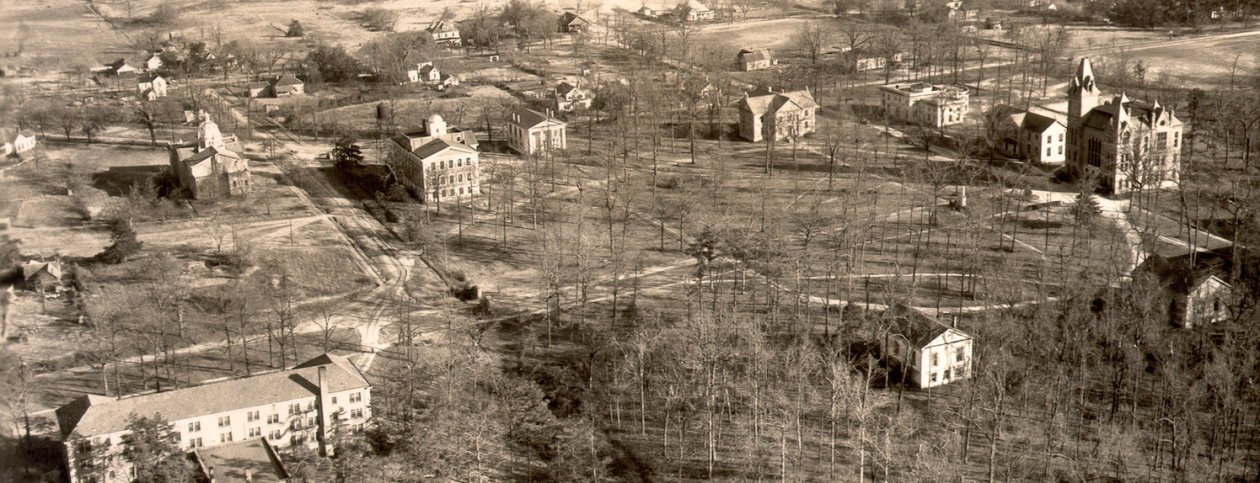
Two questions about the Atlanta campus have long puzzled me, and finally I have the answer to one. It concerns the chunk of land that was the original nugget of today’s 740-acre campus (not counting the 42 acres of the Briarcliff property a mile away).

In addition to his initial million-dollar gift to help launch the new university in Atlanta, Asa Candler Sr. arranged to convey to Emory 75 acres belonging to Druid Hills, Inc., the corporation through which he was developing the suburb six miles from downtown Atlanta. On March 31, 1915, the university board of trustees voted, in the words of the minutes, that “the property known as the ‘Guess Place,’ located in Druid Hills, be selected as the site of the University, provided it could be secured.”

On June 28, 1915, Asa Candler, president of Druid Hills, Inc., saw to it that the land was indeed “secured.” Below, courtesy of the University’s Office of General Counsel, is a copy of the first page of the deed with that date.

Deed, 1915 original Emory Atlanta campus, 75 acres copy

I’d always assumed that the original property included the Quadrangle, but was that correct? The second page of the deed tells more:

Deed, p 2, 1915 original Emory Atlanta campus, 75 acres copy

The first paragraph above describes the exact boundaries of the property. Using Google Maps and a scale of 200 feet to half an inch, I traced as nearly as I could the boundaries laid out by the deed. Surprisingly, here is what I found:

75 acres

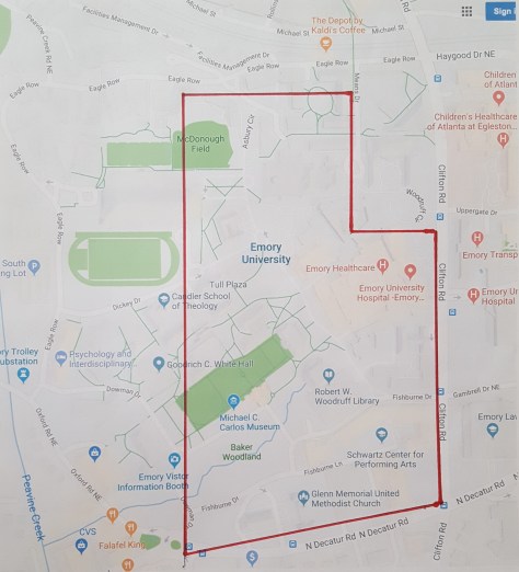
It’s interesting that those 75 acres did not include the corner at Clifton and Eagle Row, where the Woodruff Health Sciences Center now stands, or even the land where the Anatomy and Physiology laboratories would be built in 1917 (current site of the School of Medicine). More curious still, the western boundary appears to cut through the edge of the Quadrangle at about where architect Henry Hornbostel would locate the Old Theology Building.

Nine years later, the board minutes of May 30, 1924, indicate that Druid Hills, Inc., deeded to Emory an additional 55 acres, extending the western boundary of the campus to “Lullwater Creek.” That probably was what we today call Peavine Creek, which flows through Emory Village and north toward South Peachtree Creek. (Peavine Creek and Lullwater Creek meet up near the 15th tee of the Druid Hills Golf Club, just south of Emory Village. To my inexpert eye, it appears that Peavine actually flows into Lullwater, and that Lullwater continues on, and maybe folks in 1924 thought the same thing.)

By 1936, according to historian Henry Morton Bullock, in his centennial history of Emory, “subsequent additions” had “increased the campus to 235 acres.”

Now to take up the second question–who was that Guess for whom “the Guess place” was named?

Gary Hauk

Advertisement

The water tower and the golfer

It stood above the campus like a sentry, as if to guard against drought and keep watch for welcome rain clouds on the horizon. In my recollection it was always blue, though not Emory blue–more like the blue of a robin’s egg.

It should have been painted white, with trompe l’oeil stippling to mimic the look of a golf ball. Because after I heard someone refer to it as “the Bobby Jones Memorial,” I could never again see it as anything but a golf ball on a tee. (Bobby Jones was the Emory alumnus who graduated from the law school in 1929 and went on, the following year, to become the only person ever to win the grand slam of golf. Some of his papers — and a bronzed golf shoe! — are held in the Stuart A Rose Manuscript, Archives, and Rare Book Library.)

water-tower-in-r-d-cole-catalogue-copy
The old water tower on Emory’s campus resembled a golf ball on a tee. The tower appears here in the catalogue of the manufacturer.

The tower was installed in 1933 and made it into the pages of the November-December 1933 Emory Alumnus.

water-tower-in-emory-alumnus

By 2007 the water tower, in terms that Bobby Jones would have been familiar with, had become a waterless hazard. It had not held water since the 1980s, and improvements to maintain its structural integrity were estimated to cost several hundred thousands of dollars. While realigning Eagle Row to make way for new residence halls, the university dismantled the tower and recycled its steel.

I learned recently that Mathew Pinson, senior director of development in the Candler School of Theology, has a personal connection to that bygone tower. His great-grandfather, Bryan M. Blackburn, was employed by R.D. Cole Manufacturing Company in Newnan, Georgia, when he patented the design of the hundred-thousand-gallon tank. Mathew shared images of the design that was approved by the US Patent Office on February 20, 1934 (after the tower had been installed at Emory). The patent and the catalogue from the R.D. Cole Manufacturing Company are in the Pinson family archives.

water-tower-patent-diagram

water-tower-patent-diagram-2

Great-grandfather Blackburn was a member of the twenty-fifth graduating class of Georgia Tech and began developing this design while he was a student.

Great thanks to Mathew for sharing these design images and the information about his ancestor.

Curiously, Emory University was not the only Emory with a water tower that resembled a golf ball on tee. Check out the one from Emory, Texas, below. I believe ours was built first–and unfortunately had to be removed first.

emory-texas-water-tower

Gary Hauk

Into the Woods

Just down the hill from the Miller-Ward Alumni House, on Houston Mill Road, is the entrance to Hahn Woods, formally known as the T. Marshall Hahn Commemorative Forest.

Hahn Woods parking lot
The parking lot at Hahn Woods.

This Emory landmark came to mind last week when I learned of the passing of the man for whom the woods are named—T. Marshall Hahn Jr., Emory trustee emeritus and former CEO of Georgia-Pacific. Among his achievements were a PhD in physics from MIT at the age of 23 and appointment at the age of 35 to the presidency of Virginia Tech, which he built into a research university during his tenure from 1962 to 1974. His obituary from the Roanoke (Va.) Times is here. Marshall had served as chair of the Emory trustees’ Investment Committee and a member of the Executive Committee until his elevation to emeritus status at age 70 in 1997. He blended academic aspiration and business acumen in an extraordinary way.

Hahn Woods is well worth a visit. A stroll along its paths not only leads into a literal grove of academe but also introduces something of the area’s history.

Hahn Woods marker

This 4.7-acre preserve was part of a 60-acre parcel that the university acquired from the owners of the Houston Mill House in 1960. In the succeeding decades Emory covered over a pasture and a swimming pool with construction debris, creating a landfill.

Hahn Woods meadow
The meadow at Hahn Woods formerly was used by Emory as a dump for construction debris. Before Emory acquired the land from the Harry Carr family, in 1960, a swimming pool had been on the site.

In 1993, through a partnership with Georgia-Pacific, which sought to honor its retiring CEO, the university began reclaiming the site as a teaching area for environmental preservation—an effort dear to Marshall’s interests.

Entering the woods from the parking lot, you have a choice between an upper trail, leading past the meadow, or a lower trail that skirts the creek.

Hahn Woods path
The beginning of the lower trail in Hahn Woods

Washington Jackson Houston (pronounced HOUSE-ton) chose this site along the South Fork of Peachtree Creek for his mill, for which the nearby road is named. Houston acquired the property in 1842 from his father, Dr. Chapmon Powell, who had settled in the Decatur area in the 1820s and is buried with his wife and other family members in the cemetery on Emory’s Clairmont Campus.

Houston built a dam in the ravine to the east of the road.

Houston Mill dam
Houston Mill dam today

Just downstream stand the remains of a single-lane bridge that once carried traffic on Houston Mill Road across the creek. This iron bridge was replaced by a concrete bridge in 1952—the same concrete bridge still used by hundreds of commuters daily.

Houston Mill old bridge
The remains of Washington Jackson Houston’s iron bridge.

Pillars mark the path leading past the dam.

Hosuton Mill stone pillars

Around 1900 Houston converted his mill operations from grinding grist to generating electricity.

In the 1920s Harry Carr acquired the property and resumed grist milling. He built his Houston Mill House in 1925—the same year that Walter Candler developed his Lullwater estate half a mile upstream. Following Carr’s death in 1958—again, coincidentally, the year Emory acquired Lullwater—Emory in 1960 negotiated the purchase of the property from his widow with the provision that she be permitted to live in the house until her death. She died in 1976.

Hahn Woods lower trail
The lower trail, looking upstream toward the bend to the parking lot at Hahn Woods.

Hahn Woods now hides a lot of history but still retains traces of the past on which Emory’s campus has been built.

Gary Hauk

Amazing how things have changed . . .

This year Emory is observing the centennial of its university charter (replacing the 1836 charter as a college) and celebrating a hundred years of making Atlanta its home town. How to measure change at a place during a century? There are many ways, but one is to look at some numbers at the beginning, midway, and now.

For instance, in 1915 Emory conferred 148 degrees; in 1964-65, 1,136; in 2015, more than 4,600.

In 1915 there were 61 members of the faculty, including 16 in Emory College, which was still in Oxford. There were no endowed professorships. By 1965 the faculty had grown to 200, with twelve endowed Charles Howard Candler Professors and three or four other endowed chairs. This year there are more than 3,000 full-time faculty members, about half of them in the School of Medicine. Nearly 200 faculty members hold endowed professorships.

In 1915 the enrollment of the entire university was 631 students; in 1965 that number had grown to 5,844; this year it is 14,769, with students hailing from more than a hundred countries.

One literally concrete measure of what has happened at Emory since 1965 is all the facilities that did not exist or were not owned by Emory fifty years ago. Here is Emory as it is today.

Emory in 2015

This  map of the main Atlanta campus does not include the Briarcliff property and, of course, the historic and still vibrant campus at Oxford.

Here is the same map indicating all the buildings that Emory has added since 1965.

What's been built since 1965

All of those yellow shapes are buildings that did not exist in 1965. No wonder alumni sometimes don’t recognize the place when they return! If I printed the list here the names of the buildings would number more than fifty—more than one building a year for the past 50 years. And this does not include the new library, science center, and three new residence halls at Oxford (and the new dining hall under way there), or the nine-story hospital bed tower going up on Clifton Road, or the renovation (sometimes twice) of everything that previously existed on both campuses.

What these maps highlight is the increase in scholarly activity, teaching activity, and social activity that makes a university a university.

I’ll include more measures of change in future posts.

Gary Hauk